Canoe & Kayak Paddling in Northwest Wisconsin
Looking for your next water adventure?
From a peaceful flat water float to an exhilarating whitewater experience, paddling enthusiasts from beginner to expert will find the perfect waterway. You will also find amazing scenery and excellent fishing, so pack your fishing gear, camera and maybe an extra set of clothes—just in case!
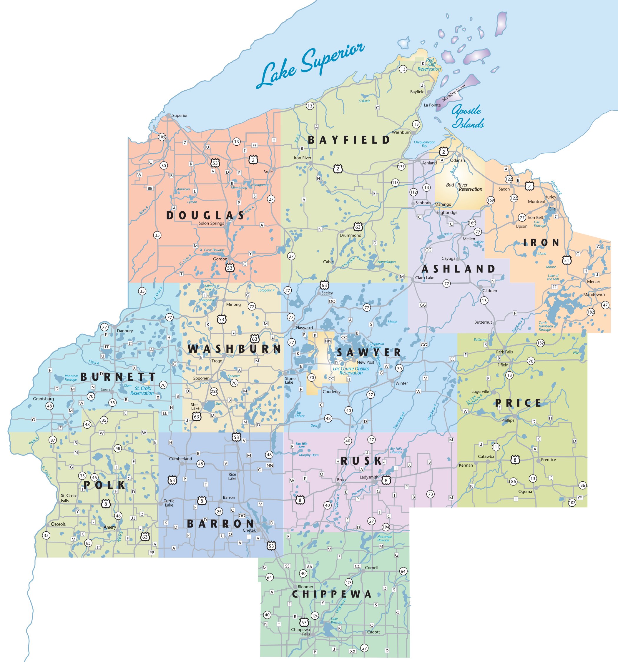
Locator Map
Please hover over icon on the map to see more info.
Apostle Islands National Lakeshore
Ashland County
Length/Landings: Madeline Island
Access at Big Bay State Park Enjoy World Class Sea Kayaking through Madeline Island with spectacular views of the Apostle Islands. Launch at Big Bay State Park to tour mainland sea caves. Guide services available.
Marker 2Apostle Islands National Lakeshore
Bayfield County
Length/Landings: Landing at Meyers Beach near the mainland sea caves and at many other locations on the Bayfield peninsula to access the Apostle Islands.
Marker 3Apple River
Polk County
The Apple River, which flows through Amery, is famous throughout the region as a popular place for tubing, kayaking and canoeing. There is a new canoe and kayak portage around the Amery Dam. The Apple River is a 77.5-mile long tributary of the St. Croix River.
Marker 4Bark Bay Slough
Bayfield County
A 552-acre shore wetland and open bog with sand spit, lagoon, springs and wetlands along a bay between two rocky headlands of the Lake Superior coast.
Marker 5Bois Brule River
Douglas County
Length/Landings: 44 Miles.
This unique, 44-mile-long river varies from a meandering stream in a conifer bog to a fast flowing river with numerous rapids and ledges. As it flows north, the Brule River drops 418 feet in elevation, plunging 328 feet in just the last 19 miles.
Marker 6Brunet Island-Chippewa River
Chippewa County
The waters that surround Brunet Island provide an outstanding paddling experience. In addition to the main island, there are a number of undeveloped islands separated by narrow channels. Go explore.
Marker 7Chippewa Moraine Glacial Lakes
Chippewa County
These cluster of lakes in the Chippewa Moraine State Recreation Area offers a "Mini Boundary Waters" type experience. Small in size but wonderfully wild. Great for canoe and kayak enthusiasts.
Marker 8Chippewa River
Rusk County
Length/Landings: Approx. 32 miles; Multiple landings.
Relatively wide and curving, with lots of deep holes. A variety of paddles with great fishing and scenery. Famous fishery for walleye and musky, as well as smallmouth, northern pike and panfish.
Marker 9Copper Falls State Park
Ashland County
Length/Landings: Copper Falls State Park; Access at Loon Lake.
Location: 2 miles NE of Mellen.
Take State Hwy 13 to the north side of Mellen and turn (NE) on State Hwy 169. Go about 1.8 miles. The park entrance will be on your left.
Marker 10Gile Flowage
Iron County
3380 acres. Four public launch sites for canoes and kayaks.
Marker 11Flambeau River
Rusk County
Length/Landings: Approx. 40 miles, including North & South Fork; multiple landings and campsites.
One of the best paddling experiences in the Midwest, with whitewater and slower stretches, on a largely undeveloped river featuring deep woodland habitat.
Marker 12Jump River
Rusk County
Length/Landings: 10 miles from Jump River to Sheldon.
Free- flowing, pristine, and dam-free for its entire length, from its source to its confluence with the Chippewa. Much of this pristine river receives little or no fishing pressure. Expect lots of musky, sucker, some walleye and smallmouth.
Marker 13Lake Wissota-Chippewa River
Chippewa County
Lake Wissota is the longest flat-water paddling opportunity on the Chippewa River. The lake can be accessed through the Lake Wissota State Park, which features a boat landing and a full range of amenities including canoeing and kayaking.
Marker 14Manitowish River Trail
Iron County
Length/Landings: 20 miles; multiple landings.
This is a 20-mile novice trail with many options for put in and take out. The river is a clean sandy bottom with a steady current. There are common access points off of Hwy 51 south of Mercer.
Marker 15Namekagon River
Bayfield, Burnett, Sawyer & Washburn Counties
Length/Landings: 99.5 miles.
Part of the St. Croix National Scenic Riverway managed by the National Park Service, the Namekagon River: Wisconsin's Moving National Park offers incredible canoeing and kayaking opportunities. This well-marked river trail offers multiple landings, river-side camping, rentals and shuttle service.
Marker 16North Fork Flambeau River: City of Park Falls to Nine Mile Creek
Price County
Length/Landings: 12 miles/6 hours; 4 landings. Hines Park & Campground, Saunders Avenue, Park Falls.
This is a relaxing journey over calm water with excellent fishing and camping opportunities. Avoid two of the four portages by starting at the Highway 13 Bridge. Easy/Moderate.
Marker 17North Fork Flambeau River: Turtle Dam to City of Park Falls
Price County
Length/Landings: 18 miles/8 hours; 4 landings. Robinson Landing, Flambeau Dam Road, Mercer WI.
A mix of whitewater and wild scenery for the first 13 miles, then flat water paddling until the landing at Hines Park and Campground. Moderate/Difficult.
Marker 18Red Cedar River
Barron County
Length/Landings: 34 miles; Access in Mikana. 34 miles on the Red Cedar River starting at Mikana, in northeast Barron County, and having a variety of access points while passing through the communities of Rice Lake, Cameron and Sand Creek before joining with the Chippewa River.
Marker 19Sawmill & Loyhead Portage Routes
Washburn County
Length: Varies. Two primitive canoe/kayak routes located north of Birchwood near Sawmill Campground.
Offers a high density of small glacial lakes. A canoe portage system has been marked to guide paddlers through this beautiful, remote area of Northern Wisconsin.
Marker 20South Fork Flambeau River: Fifield to County Road F
Price County
Length/Landings: 12 miles/5 hours; 3 landings. Movrich Memorial Community Park, N14022 Willow Ave, Fifield.
The first half of this paddle has a meandering character - the second half has some challenging whitewater. Check water levels before venturing out; best in spring or early summer. Moderate/Difficult.
Marker 21South Fork, Flambeau River-County Highway F to County Highway W
Sawyer County
Length/Landings: 10 miles/4 hours; 3 landings. several challenging rapids. Check water levels before venturing out; best in spring or early summer. Moderate/Difficult.
Marker 22St. Croix River
Burnett County
Length/Landings: 50 miles in Burnett County (169 Total); Multiple landings. National Park, camping, picnicking, fishing, wildlife. Restrooms at most official landings. Wild river, diverse terrain, mostly forested. Rapids. Historic towns.
Marker 22St. Croix River
Burnett County
Length/Landings: 50 miles in Burnett County (169 Total); Multiple landings. National Park, camping, picnicking, fishing, wildlife. Restrooms at most official landings. Wild river, diverse terrain, mostly forested. Rapids. Historic towns.
Marker 22St. Croix River
Burnett County
Length/Landings: 50 miles in Burnett County (169 Total); Multiple landings. National Park, camping, picnicking, fishing, wildlife. Restrooms at most official landings. Wild river, diverse terrain, mostly forested. Rapids. Historic towns.
Marker 23St. Croix River
Douglas County
Length: 12 miles. Canoe landing located at Gordon Dam County Park, where the St. Croix river begins.
Marker 24St. Croix River
Polk County
Length: 43 miles long, multiple landings, National Park, camping, picnicking, fishing, wildlife. Wild river, diverse terrain. Paddleboat tours available daily in summer and on weekends in fall.
Marker 25Thornapple River
Rusk County
Length/Landings: Approx. 20 miles total.
Best paddling in higher water. The archetypal Northwoods River. Very little development along the shores. Navigable for nearly all of its length.
Marker 26Turtle Flambeau Designated Quiet Area
Iron County
This area is accessed off of Murray’s Landing south of Mercer. This is a voluntary quiet area for those seeking a wilderness experience. There are many camping opportunities.
Marker 27Turtle River Trail
Iron County
Length/Landings: Connects 17 different lakes; Multiple landings. This trail connects 17 different lakes with many put in and take out options. There are several class I and II rapids that sometimes require a portage. The most common access is along County H in Mercer.
Marker 28Yellow River
Burnett & Washburn Counties
Length/Landings: 50 miles in Burnett, 12 miles in Washburn; Multiple landings. This beautiful river is narrow and meanders through farmland, wetland, forest and flows through two lakes.